File:ArmenianGenocideRecognition.png
Jump to navigation
Jump to search

Size of this preview: 800 × 406 pixels. Other resolutions: 320 × 162 pixels | 640 × 325 pixels | 1,024 × 520 pixels | 2,000 × 1,015 pixels.
Original file (2,000 × 1,015 pixels, file size: 307 KB, MIME type: image/png)
| This free media file is from Wikimedia Commons. Its description page is included below. |

|
File:Nations recognising the Armenian Genocide.svg is a vector version of this file. It should be used in place of this PNG file when not inferior.
File:ArmenianGenocideRecognition.png → File:Nations recognising the Armenian Genocide.svg
For more information, see Help:SVG. |
 |
Summary
| Description |
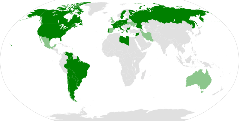
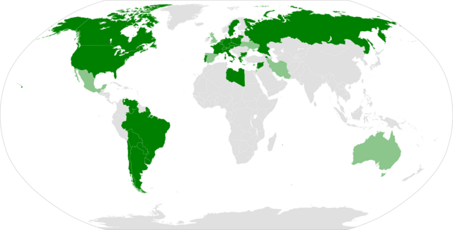
English: Political map showing countries which have described the Armenian Genocide with laws or resolutions. Green: national parliament. |
| Source | Own work |
| Author | 334a |
| Other versions | Image:BlankMap-World.png |
Licensing
| I, the copyright holder of this work, release this work into the public domain. This applies worldwide. In some countries this may not be legally possible; if so: I grant anyone the right to use this work for any purpose, without any conditions, unless such conditions are required by law. |
File history
Click on a date/time to view the file as it appeared at that time.
| Date/Time | Thumbnail | Dimensions | User | Comment | |
|---|---|---|---|---|---|
| current | 20:11, 30 October 2019 | | 2,000 × 1,015 (307 KB) | Mathsquare | Download the PNG version of https://commons.wikimedia.org/wiki/File:Nations_recognising_the_Armenian_Genocide.svg which is more updated. Thanks to me. No reason to have two different versions on the site. |
| 01:26, 30 October 2019 |  | 1,480 × 625 (48 KB) | Gomoloko | +portugal | |
| 20:57, 14 July 2019 |  | 1,480 × 625 (48 KB) | Adûnâi | Libya coloured green | |
| 15:00, 14 July 2019 |  | 1,480 × 625 (48 KB) | Adûnâi | Alabama coloured green | |
| 02:51, 28 May 2018 |  | 1,480 × 625 (48 KB) | Forthrunner | South Sudan already had a border. That was just a PNG copy of the SVG file | |
| 22:02, 24 March 2018 |  | 2,000 × 1,027 (301 KB) | Maphobbyist | South Sudan border | |
| 21:11, 3 December 2017 |  | 1,480 × 625 (48 KB) | Forthrunner | Updates | |
| 01:48, 18 June 2015 |  | 1,480 × 625 (48 KB) | Leftcry | Nagorno-Karabakh | |
| 13:04, 10 June 2015 |  | 1,480 × 625 (57 KB) | Gartok~commonswiki | Brazil and Luxembourg have recognized it at the national level. Recognition of it also applies to Bulgaria - even if the specific word "genocide" is not mentioned, but is mentioned as "mass extermination". | |
| 02:53, 25 April 2015 |  | 1,480 × 625 (49 KB) | Leftcry | Fix US map |
File usage
The following 2 pages use this file:
Global file usage
The following other wikis use this file:
- Usage on af.wikipedia.org
- Usage on ar.wikipedia.org
- Usage on ast.wikipedia.org
- Usage on bg.wikipedia.org
- Usage on ca.wikipedia.org
- Usage on ce.wikipedia.org
- Usage on el.wikipedia.org
- Usage on en.wikipedia.org
- Usage on eo.wikipedia.org
- Usage on es.wikinews.org
- Usage on frp.wikipedia.org
- Usage on fr.wikinews.org
- Usage on gl.wikipedia.org
- Usage on hr.wikipedia.org
- Usage on hy.wikipedia.org
- Usage on hyw.wikipedia.org
- Usage on jv.wikipedia.org
- Usage on ms.wikipedia.org
- Usage on nl.wikipedia.org
- Usage on no.wikipedia.org
- Usage on ru.wikipedia.org
- Usage on sc.wikipedia.org
- Usage on sk.wikipedia.org
- Usage on sv.wikipedia.org
- Usage on tr.wikipedia.org