File:2004 indian ocean earthquake details.png
2004_indian_ocean_earthquake_details.png (413 × 408 pixels, file size: 26 KB, MIME type: image/png)
| This free media file is from Wikimedia Commons. Its description page is included below. |
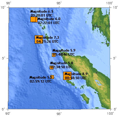
The 2004 Indian Ocean earthquake. There are 7 earthquakes on this map as of 17:00 UTC, December 26, 2004.
The original image was generated by the USGS and was found at https://earthquake.usgs.gov/recenteqsww/Maps/10/95_5.html -- Toytoy 17:40, Dec 26, 2004 (UTC).
The original image:
This image is in the public domain in the United States because it only contains materials that originally came from the United States Geological Survey, an agency of the United States Department of the Interior. For more information, see the official USGS copyright policy.
|
en:User:Toytoy's modification:
- You are free:
- to share – to copy, distribute and transmit the work
- to remix – to adapt the work
- Under the following conditions:
- attribution – You must give appropriate credit, provide a link to the license, and indicate if changes were made. You may do so in any reasonable manner, but not in any way that suggests the licensor endorses you or your use.
- share alike – If you alter, transform, or build upon this work, you must distribute the resulting work under the same license as the original.
Note: many of the magnitudes and times of the earthquakes shown here have been revised since:
- 8.9 -> 9.0 (00:58:53) [1] archive copy at the Wayback Machine [2] archive copy at the Wayback Machine
- 7.3 -> 7.1 (04:21:29) [3] archive copy at the Wayback Machine
- 6.5 -> 6.6 (09:20:00) [4]
- 6.0 -> 5.8 [5] archive copy at the Wayback Machine
- 5.9 (02:59:12) -> 5.7 (02:59:14) [6] archive copy at the Wayback Machine
- 5.9 (01:48:46) -> 5.8 (01:48:49) [7] archive copy at the Wayback Machine
- 5.8 -> 5.7 (02:34:52) [8] archive copy at the Wayback Machine
Also, many more aftershocks have occurred. Therefore this image is out of date.
Original upload log
| Date/Time | Dimensions | User | Comment |
|---|---|---|---|
| 31 December 2004, 02:45:36 | 413 × 408 (31787 bytes) | Amgine (talk · contribs) | The '''[[2004 Indian Ocean earthquake]]'''.There are 7 earthquakes on this map as of 17:00 UTC, December 26, 2004. |
File history
Click on a date/time to view the file as it appeared at that time.
| Date/Time | Thumbnail | Dimensions | User | Comment | |
|---|---|---|---|---|---|
| current | 09:31, 21 July 2014 | | 413 × 408 (26 KB) | GifTagger | Bot: Converting file to superior PNG file. (Source: 2004_indian_ocean_earthquake_details.gif). This GIF was problematic due to non-greyscale color table. |
File usage
No pages on the English Wikinews link to this file. Pages on other Wikimedia projects are not listed here.
Global file usage
The following other wikis use this file:
- Usage on de.wikipedia.org
- Usage on en.wikipedia.org
- Usage on ga.wikipedia.org
- Usage on id.wikipedia.org
- Usage on ms.wikipedia.org
- Usage on nl.wikipedia.org
- Usage on no.wikipedia.org
- Usage on pl.wikipedia.org
- Usage on zh.wikipedia.org