File:2006 North Korean nuclear test.svg
Jump to navigation
Jump to search

Size of this PNG preview of this SVG file: 473 × 408 pixels. Other resolutions: 278 × 240 pixels | 557 × 480 pixels | 890 × 768 pixels | 1,187 × 1,024 pixels | 2,374 × 2,048 pixels.
Original file (SVG file, nominally 473 × 408 pixels, file size: 71 KB)
| This free media file is from Wikimedia Commons. Its description page is included below. |
Summary
| Description |
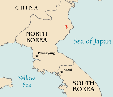
Map of the North Korean nuclear test of October 9, 2006. The red marker indicates the estimated location of the test (41.311°N, 129.114°E). Based off of maps from the CIA World Factbook. |
| Date | 10 October 2006 (original upload date) |
| Source | No machine-readable source provided. Own work assumed (based on copyright claims). |
| Author | No machine-readable author provided. Mobius assumed (based on copyright claims). |
| Other versions |
|


Licensing
| I, the copyright holder of this work, release this work into the public domain. This applies worldwide. In some countries this may not be legally possible; if so: I grant anyone the right to use this work for any purpose, without any conditions, unless such conditions are required by law. |
File history
Click on a date/time to view the file as it appeared at that time.
| Date/Time | Thumbnail | Dimensions | User | Comment | |
|---|---|---|---|---|---|
| current | 20:48, 10 October 2006 | | 473 × 408 (71 KB) | Mobius | + Crop area, proper license |
| 20:43, 10 October 2006 |  | 981 × 801 (71 KB) | Mobius | Map of the North Korean nuclear test of October 9, 2006. The red marker indicates the estimated location of the test (41.311°N, 129.114°E). Based off of maps from the CIA World Factbook. |
File usage
No pages on the English Wikinews link to this file. Pages on other Wikimedia projects are not listed here.
Global file usage
The following other wikis use this file:
- Usage on ca.wikipedia.org
- Usage on en.wikipedia.org
- Usage on ia.wikipedia.org
- Usage on ko.wikipedia.org
- Usage on nl.wikipedia.org
- Usage on no.wikipedia.org
- Usage on pl.wikinews.org
- Usage on ta.wikinews.org
- Usage on www.wikidata.org