File:Africa independence dates.PNG
Jump to navigation
Jump to search

Size of this preview: 564 × 600 pixels. Other resolutions: 226 × 240 pixels | 451 × 480 pixels | 752 × 800 pixels.
Original file (752 × 800 pixels, file size: 42 KB, MIME type: image/png)
| This free media file is from Wikimedia Commons. Its description page is included below. |

|
File:Africa independence dates.svg is a vector version of this file. It should be used in place of this PNG file when not inferior.
File:Africa independence dates.PNG → File:Africa independence dates.svg
For more information, see Help:SVG. |
 |
Summary
Español: Fechas de independencia de los países africanos.
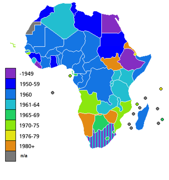
Countries of Africa, with date of independence
Licensing

|
Permission is granted to copy, distribute and/or modify this document under the terms of the GNU Free Documentation License, Version 1.2 or any later version published by the Free Software Foundation; with no Invariant Sections, no Front-Cover Texts, and no Back-Cover Texts. A copy of the license is included in the section entitled GNU Free Documentation License. |
| This file is licensed under the Creative Commons Attribution-Share Alike 3.0 Unported license. | ||
| ||
| This licensing tag was added to this file as part of the GFDL licensing update. |
File history
Click on a date/time to view the file as it appeared at that time.
| Date/Time | Thumbnail | Dimensions | User | Comment | |
|---|---|---|---|---|---|
| current | 04:25, 9 July 2011 | | 752 × 800 (42 KB) | Hoshie | added South Sudan to the map |
| 02:34, 19 June 2011 |  | 752 × 800 (42 KB) | Muso | Reverted to version as of 10:09, 22 April 2011 | |
| 02:19, 19 June 2011 |  | 752 × 800 (14 KB) | Muso | Zimbabwe got his independence in 1965, therefore correct its color from orange green | |
| 10:09, 22 April 2011 |  | 752 × 800 (42 KB) | Hoshie | added the French departements of Mayotte and Reunion and the Ilies Eparses distict of the TAAF; CIA maps was used as a source. A version w/ Southern Sudan is ready for July. | |
| 03:00, 11 April 2011 |  | 752 × 800 (42 KB) | Hoshie | added Cabinda (Angola) to the map; a version with Southern Sudan is ready once they declare independence in July. | |
| 18:16, 6 April 2010 |  | 752 × 800 (38 KB) | Lemonade100 | De Jure Independance of Zimbawe and South Africa (changed from de facto), St Helena and dependancies added. | |
| 01:35, 23 March 2008 |  | 752 × 690 (36 KB) | Serg!o | UN considers Sahara as a colony - ONU considera Sahara como colonia | |
| 11:44, 22 March 2006 |  | 752 × 690 (36 KB) | Roke~commonswiki | Countries of Africa, with date of independence Category: Maps of Africa Category: History of Africa |
File usage
No pages on the English Wikinews link to this file. Pages on other Wikimedia projects are not listed here.
Global file usage
The following other wikis use this file:
- Usage on bn.wikipedia.org
- Usage on el.wikivoyage.org
- Usage on en.wikipedia.org
- Usage on hi.wikipedia.org