File:Carte Tour de France 2009.png
Jump to navigation
Jump to search

Size of this preview: 547 × 599 pixels. Other resolutions: 219 × 240 pixels | 438 × 480 pixels | 975 × 1,068 pixels.
Original file (975 × 1,068 pixels, file size: 280 KB, MIME type: image/png)
| This free media file is from Wikimedia Commons. Its description page is included below. |
Summary
| Description |
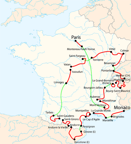
Français : Carte du Tour de France 2009 avec les noms de villes en français. Les cours d'eau en Espagne ne sont pas réels et n'ont qu'une valeur illustrative. |
| Date | |
| Source | travail personnel et modification des cartes du Tour déjà existantes File:Tour-de-France-2009.png |
| Author | NielsB |

|
This sport map image could be re-created using vector graphics as an SVG file. This has several advantages; see Commons:Media for cleanup for more information. If an SVG form of this image is available, please upload it and afterwards replace this template with
{{vector version available|new image name}}.
It is recommended to name the SVG file “Carte Tour de France 2009.svg”—then the template Vector version available (or Vva) does not need the new image name parameter. |
Licensing
I, the copyright holder of this work, hereby publish it under the following license:
This file is licensed under the Creative Commons Attribution-Share Alike 3.0 Unported license.
- You are free:
- to share – to copy, distribute and transmit the work
- to remix – to adapt the work
- Under the following conditions:
- attribution – You must give appropriate credit, provide a link to the license, and indicate if changes were made. You may do so in any reasonable manner, but not in any way that suggests the licensor endorses you or your use.
- share alike – If you remix, transform, or build upon the material, you must distribute your contributions under the same or compatible license as the original.
File history
Click on a date/time to view the file as it appeared at that time.
| Date/Time | Thumbnail | Dimensions | User | Comment | |
|---|---|---|---|---|---|
| current | 19:32, 13 June 2009 | | 975 × 1,068 (280 KB) | Nakor | Correct color in SW France. |
| 12:33, 5 November 2008 |  | 975 × 1,068 (213 KB) | Kapowski~commonswiki | {{Information |Description={{fr|1=Carte du Tour de France 2009 avec les noms de villes en français. Les cours d'eau en Espagne ne sont pas réels et n'ont qu'une valeur illustrative.}} |Source=travail personnel et modification des cartes du Tour déjà e |
File usage
The following page uses this file:
Global file usage
The following other wikis use this file:
- Usage on cs.wikipedia.org
- Usage on cy.wikipedia.org
- Usage on de.wikipedia.org
- Usage on en.wikipedia.org
- Usage on fr.wikipedia.org
- Usage on fr.wikinews.org
- Usage on hu.wikipedia.org
- Usage on it.wikipedia.org
- Usage on ja.wikipedia.org
- Usage on ky.wikipedia.org
- Usage on la.wikipedia.org
- Usage on lt.wikipedia.org
- Usage on nl.wikipedia.org
- Usage on no.wikipedia.org
- Usage on pl.wikipedia.org
- Usage on pt.wikipedia.org
- Usage on ro.wikipedia.org
- Usage on ru.wikipedia.org
- Usage on ru.wikinews.org
- Usage on sk.wikipedia.org
- Usage on sv.wikipedia.org
- Usage on vls.wikipedia.org
- Usage on wa.wikipedia.org
- Usage on zh.wikipedia.org