File:Greater Jerusalem May 2006 CIA remote-sensing map 3500px.jpg
Jump to navigation
Jump to search

Size of this preview: 463 × 599 pixels. Other resolutions: 185 × 240 pixels | 371 × 480 pixels | 593 × 768 pixels | 791 × 1,024 pixels | 1,582 × 2,048 pixels | 3,500 × 4,530 pixels.
Original file (3,500 × 4,530 pixels, file size: 5.54 MB, MIME type: image/jpeg)
| This free media file is from Wikimedia Commons. Its description page is included below. |
Note: This is a smaller 3500-pixel-wide version of the original map. The original map on the Commons is 8,264 × 10,696 pixels and has a huge file size of 53.3 MB. This 3500-pixel-wide version of the map is 5.54 MB. A warning on the page for the larger image: {{LargeImage}}
| Description |
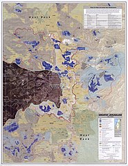
English: Greater Jerusalem, May 2006. United States. Central Intelligence Agency. CREATED/PUBLISHED [Washington, D.C.] : Central Intelligence Agency, [2006] NOTES Shows settlements, refugee camps, fences, walls, etc. "Imagery base: SPOT 5 multispectral imagery acquired July 2004." Includes chart describing plans for new settlements. "803197AI (G00307) 5-06." Scale 1:40,000 ; universal transverse Mercator proj. (E 35006'--E 35021'/N 31054'--N 310390). MEDIUM 1 remote-sensing map : col. ; 87 x 67 cm. CALL NUMBER G7504.J4G4 2006 .U5 REPOSITORY Library of Congress Geography and Map Division Washington, D.C. 20540-4650 USA DIGITAL ID g7504j ct001915 http://hdl.loc.gov/loc.gmd/g7504j.ct001915 Note:Image converted from jp2 -> jpg |
| Date | (UTC) |
| Source | This is a 3500-pixel-wide version of the above-linked original map that is 8,264 × 10,696 pixels, with a file size of 53.3 MB. This 3500-pixel-wide version is 5.54 MB. |
| Author |
|
| Other versions |
.jpg)
| This work is from the Library of Congress. According to the library, there are no known copyright restrictions on the use of this work. |  |
Original upload log
This image is a derivative work of the following images:
- File:Greater_Jerusalem_May_2006_CIA_remote-sensing_map_.jpg licensed with PD-USGov
- 2010-04-24T11:10:11Z Sean.hoyland 8264x10696 (55888328 Bytes) {{Information |Description={{en|1=Greater Jerusalem, May 2006. United States. Central Intelligence Agency. CREATED/PUBLISHED [Washington, D.C.] : Central Intelligence Agency, [2006] NOTES Shows settlements, refugee camps, fe
Uploaded with derivativeFX
File history
Click on a date/time to view the file as it appeared at that time.
| Date/Time | Thumbnail | Dimensions | User | Comment | |
|---|---|---|---|---|---|
| current | 06:15, 3 October 2010 | | 3,500 × 4,530 (5.54 MB) | Timeshifter | {{Information |Description={{en|1=Greater Jerusalem, May 2006. United States. Central Intelligence Agency.<br> CREATED/PUBLISHED<br> [Washington, D.C.] : Central Intelligence Agency, [2006]<br> NOTES<br> Shows settlements, refugee camps, fences, walls, e |
File usage
No pages on the English Wikinews link to this file. Pages on other Wikimedia projects are not listed here.
Global file usage
The following other wikis use this file:
- Usage on ar.wikipedia.org
- Usage on arz.wikipedia.org
- Usage on azb.wikipedia.org
- Usage on de.wikipedia.org
- Usage on en.wikipedia.org
- Usage on eo.wikipedia.org
- Usage on es.wikipedia.org
- Usage on id.wikipedia.org
- Usage on ja.wikipedia.org
- Usage on nn.wikipedia.org
- Usage on no.wikipedia.org
- Usage on or.wikipedia.org
- Usage on pt.wikipedia.org
- Usage on ru.wikipedia.org
- Usage on sl.wikipedia.org
- Usage on ta.wikipedia.org
- Usage on tl.wikipedia.org
- Usage on tr.wikipedia.org
- Usage on zh.wikipedia.org