File:Helios airways flight 522 en remi.png
Jump to navigation
Jump to search

Size of this preview: 800 × 500 pixels. Other resolutions: 320 × 200 pixels | 640 × 400 pixels | 1,024 × 640 pixels | 1,440 × 900 pixels.
Original file (1,440 × 900 pixels, file size: 406 KB, MIME type: image/png)
| This free media file is from Wikimedia Commons. Its description page is included below. |

|
This incident map image could be re-created using vector graphics as an SVG file. This has several advantages; see Commons:Media for cleanup for more information. If an SVG form of this image is available, please upload it and afterwards replace this template with
{{vector version available|new image name}}.
It is recommended to name the SVG file “Helios airways flight 522 en remi.svg”—then the template Vector version available (or Vva) does not need the new image name parameter. |
Summary
| Description |
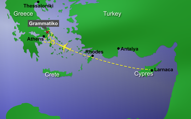
Map of Helios Airways Flight 522. Helios Airwyas Flight 522, crashed on August 14, 2005 near the community of Grammatiko in Greece. The map shows how the flight proceeded. First, the autopilot controlled the airplane in the direction of Athens airport. Then the airplane flew to the south and in loops over the Aegean Sea for about three hours. After that, the airplane flew in the direction of Athens airport again, until it crashed near Grammatiko. |
| Date | |
| Source | graphic created by remi |
| Author | remi |
| Permission (Reusing this file) |
remi put it under the GFDL |
| Other versions |
This graphic is available in different languages.
|
Links
- en:Helios Airways Flight 522
- id:Helios Airways Penerbangan 522
- please edit and complete this list
Translations
If you need the map in another language, please look at Image_talk:Helios_airways_flight_522_en_remi.png.
Licensing
I, the copyright holder of this work, hereby publish it under the following licenses:

|
Permission is granted to copy, distribute and/or modify this document under the terms of the GNU Free Documentation License, Version 1.2 or any later version published by the Free Software Foundation; with no Invariant Sections, no Front-Cover Texts, and no Back-Cover Texts. A copy of the license is included in the section entitled GNU Free Documentation License. |
| This file is licensed under the Creative Commons Attribution-Share Alike 3.0 Unported license. | ||
| ||
| This licensing tag was added to this file as part of the GFDL licensing update. |
You may select the license of your choice.
File history
Click on a date/time to view the file as it appeared at that time.
| Date/Time | Thumbnail | Dimensions | User | Comment | |
|---|---|---|---|---|---|
| current | 10:39, 20 August 2005 | | 1,440 × 900 (406 KB) | Remi~commonswiki | |
| 01:34, 20 August 2005 |  | 1,440 × 900 (399 KB) | Remi~commonswiki | {{Information| |Description = Map of Helios Airways Flight 522. Helios Airwyas Flight 522, crashed on August 14, 2005 near the community of Grammatiko in Greece. |So | |
| 01:22, 20 August 2005 |  | 1,440 × 900 (399 KB) | Remi~commonswiki | Map of Helios Airways Flight 522. Helios Airwyas Flight 522, crashed on August 14, 2005 near the community of Grammatiko in Greece. Source: remi {{GF | |
| 14:05, 19 August 2005 |  | 1,440 × 900 (415 KB) | Remi~commonswiki | Helios Airwyas Flight 522, crashed on August 14, 2005 near the community of Grammatiko in Greece. Source: User:Remi - drawed by myself {{GFDL}} [[Category:Maps]]\ |
File usage
The following 3 pages use this file:
Global file usage
The following other wikis use this file:
- Usage on de.wikipedia.org
- Usage on id.wikipedia.org
- Usage on it.wikipedia.org
- Usage on ja.wikipedia.org
- Usage on ko.wikipedia.org