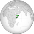
File:Somalia (orthographic projection).svg
Appearance

Size of this PNG preview of this SVG file: 553 × 553 pixels. Other resolutions: 240 × 240 pixels | 480 × 480 pixels | 768 × 768 pixels | 1,024 × 1,024 pixels | 2,048 × 2,048 pixels.
Original file (SVG file, nominally 553 × 553 pixels, file size: 263 KB)
File history
Click on a date/time to view the file as it appeared at that time.
| Date/Time | Thumbnail | Dimensions | User | Comment | |
|---|---|---|---|---|---|
| current | 08:04, 4 April 2024 |  | 553 × 553 (263 KB) | Maram089 | Reverted to version as of 07:11, 4 April 2024 (UTC) |
| 07:48, 4 April 2024 |  | 553 × 553 (362 KB) | Buufin | Reverted to version as of 07:02, 4 April 2024 (UTC) You're clearly here to build a Pan-Somalism ideology | |
| 07:11, 4 April 2024 |  | 553 × 553 (263 KB) | Maram089 | Reverted to version as of 03:19, 4 April 2024 (UTC) you are causing vandalism as we can see the lack of consensus and your insistence in adopting a map that lacks credibility | |
| 07:02, 4 April 2024 |  | 553 × 553 (362 KB) | Buufin | Reverted to version as of 22:30, 3 April 2024 (UTC) | |
| 03:19, 4 April 2024 |  | 553 × 553 (263 KB) | Salma3232 | Reverted to version as of 19:28, 3 April 2024 (UTC) Shows SSC Khatumo as part of SL inaccurate and misleading | |
| 22:30, 3 April 2024 |  | 553 × 553 (362 KB) | Buufin | Reverted to version as of 07:52, 3 April 2024 (UTC) Light green represents disputed territory | |
| 19:28, 3 April 2024 |  | 553 × 553 (263 KB) | Nawal00 | Reverted to version as of 08:01, 14 December 2023 (UTC). SSC Khatumo control 30% of territories claimed by SL, more than once city. SSC Khatumo is a federal member state recognised by the Somali Government. The current border is the dejure border recognised by the international community as Somalia | |
| 07:52, 3 April 2024 |  | 553 × 553 (362 KB) | Jethro1945 | Reverted to version as of 02:09, 14 December 2023 (UTC) Somalia does not control the territory of Somaliland. The so called Khatumo state of Somalia entity controls certain areas of eastern Somaliland that doesn’t mean Somalia controls the whole territory of Somaliland | |
| 08:01, 14 December 2023 |  | 553 × 553 (263 KB) | Maram089 | Reverted to version as of 21:03, 12 December 2023 (UTC) South Sudan is a sovereign country that has a dispute with another sovereign country Sudan. Somaliland once I searched and read is NOT sovereign neither it control the light green entity that it claims. | |
| 02:09, 14 December 2023 |  | 553 × 553 (362 KB) | Zinderboff | Reverted to version as of 18:15, 12 December 2023 (UTC) Standard procedure for dispute territories and unrecognised/partially-recognised states, if South Sudan for example with all it’s instability and lack of central government control has it’s disputed borders shown I don’t see why Somalia would be any different. |
File usage
The following 71 pages use this file:
- AU peacekeepers killed in Somalia, Islamists vow more attacks
- Al-Shabaab and AU peacekeepers clash in Somalia
- American captain freed from Somali pirates
- At least fifteen killed after suicide bombing in Somali hotel
- At least fourteen dead after rebel clashes in Somalia
- At least seventeen dead after clashes in Somalia
- At least twelve die in Mogadishu attacks
- Belgian ship hijacked off Horn of Africa by Somali pirates
- Bomb blasts in Somalia kill at least 30
- Bomb explosion in Somaliland kills four cops
- Bus explosion in Mogadishu, Somalia kills many civilians
- Deadly clashes in Somalia between police and government troops
- Dozens of people killed in Mogadishu, Somalia car bombings near Sahafi Hotel
- Drought stricken Somalia nears famine
- European Union offers to train Somali troops as fighting breaks out
- European Union to train Somali security forces
- Families appeal to Spain's government to negotiate with Somali pirates
- Fifteen killed in Somalia bombing
- First Somali president Aden Abdulle Osman Daar dies
- Fourteen dead in two attacks in Somalia
- Italian cruise ship thwarts attack by Somali pirates
- Japanese ship escapes after pirates open fire in Somalia
- Judge known for jailing pirates shot dead in Bossaso, Somalia
- Key town captured by Islamist Somali militants
- Kidnapped British couple "need urgent help"
- Leader of Somali group al-Shabaab assassinated
- Militant factions clash in Somalia
- Mortar exchange kills thirteen in Somali capital
- Mortar raid kills 15 in Somalia
- Panama-flagged ship hijacked off Somali coast by pirates
- Pirate attack on Norwegian ship foiled by NATO forces
- Pirate attacks bring UN aid to Somalia to a halt
- Pirates capture Saudi oil tanker
- Pirates kill four American hostages
- Pirates seize cargo ship in Indian Ocean
- Prime Minister Ghedi of Somalia resigns
- Shelling in Somalia's capital kills twenty
- Ship sunk by Indian navy was a fishing boat, says owner
- Somali al-Shabaab group seizes three towns
- Somali hospital hit by shells after continued unrest
- Somali interior minister killed by bomb attack in own home
- Somali minister killed by car bomb
- Somali opposition group al-Shabaab to block WFP food aid
- Somali parliament rejects president's dismissal of prime minister
- Somali pirates agree to release Egyptian ship with fertiliser cargo and 28 crew
- Somali pirates demand $2 million ransom for US captain held hostage
- Somali pirates launch attack on oil tanker
- Somali pirates release Greek-owned ship
- Somali pirates release Greek ship, 19 sailors
- Somali pirates seize Greek-owned tanker
- Somali pirates seize Greek freighter, 25 crew in the Gulf of Aden
- Somali pirates seize two European tankers, Seychelles yacht
- Somali radio stations stopped from playing music by Islamist militants
- Somalia in danger of famine
- Three aid workers released by Somali gunmen
- Two French journalists kidnapped by Somali gunmen
- Two Kenyans kidnapped by gunmen in Somalia now released
- Two Kenyans kidnapped in Somalia by gunmen
- Two UN contract workers kidnapped in Somalia
- U.N. pulls out of southern Somalia
- U.S. tugboat latest victim of Somali pirates
- UNHCR: Somalia violence killed 258 civilians last month; tens of thousands displaced
- US crew retakes ship hijacked by pirates; captain held hostage
- Ukrainian ship MV Faina with cargo of tanks freed by pirates
- Up to one-half of Somali food aid diverted from needy
- Violence in Somalia's capital kills 22 people
- Violence in Somalia displaces over 27,000
- Wikinews:Template messages/Infoboxes/Countries
- Template:Infobox/lookup/Somalia
- Template:Somalia
- Category:Somalia
Global file usage
The following other wikis use this file:
- Usage on ann.wikipedia.org
- Usage on arc.wikipedia.org
- Usage on ar.wikipedia.org
- الصومال
- الحكومة الوطنية الانتقالية
- مستخدم:جار الله/قائمة صور مقالات العلاقات الثنائية
- العلاقات الصومالية الأمريكية
- العلاقات الأنغولية الصومالية
- العلاقات الصومالية الإريترية
- العلاقات الصومالية السويسرية
- العلاقات الألمانية الصومالية
- العلاقات الصومالية الليختنشتانية
- العلاقات الصومالية البوليفية
- العلاقات الصومالية الموزمبيقية
- العلاقات الألبانية الصومالية
- العلاقات الصومالية البلجيكية
- العلاقات الصومالية البيلاروسية
- العلاقات الصومالية الطاجيكستانية
- العلاقات الصومالية الروسية
- العلاقات الصومالية الرومانية
- العلاقات الأرجنتينية الصومالية
- العلاقات الصومالية الغامبية
- العلاقات الصومالية القبرصية
- العلاقات الصومالية السيراليونية
- العلاقات الصومالية النيبالية
- العلاقات الصومالية الليبيرية
- العلاقات التشيكية الصومالية
- العلاقات الصومالية الميانمارية
- العلاقات الصومالية الكندية
- العلاقات السعودية الصومالية
- العلاقات الصومالية الزيمبابوية
- العلاقات الصومالية الإسرائيلية
- العلاقات الصومالية البالاوية
- العلاقات الصومالية المالية
- العلاقات الصومالية النيجيرية
- العلاقات الصومالية اليمنية
- العلاقات الصومالية الفانواتية
- العلاقات الصومالية الغابونية
- العلاقات الصومالية البنمية
- العلاقات الصومالية الكوبية
- العلاقات الصومالية الجورجية
- العلاقات الصومالية التونسية
- العلاقات الصومالية الكورية الشمالية
- العلاقات الصومالية الهندية
- العلاقات الصومالية اليابانية
- العلاقات الصومالية الإيطالية
- العلاقات الصومالية الناوروية
- العلاقات الأسترالية الصومالية
- العلاقات الصومالية الزامبية
- العلاقات الصومالية الفيجية
- العلاقات الصومالية المارشالية
View more global usage of this file.


