File:Stad Amsterdam in Nieuw Nederland (City Amsterdam in New Netherland) Castello Plan 1660.jpg
Jump to navigation
Jump to search

Size of this preview: 800 × 600 pixels. Other resolutions: 320 × 240 pixels | 640 × 480 pixels | 1,024 × 768 pixels | 1,280 × 960 pixels | 2,560 × 1,920 pixels | 3,888 × 2,916 pixels.
Original file (3,888 × 2,916 pixels, file size: 4.28 MB, MIME type: image/jpeg)
| This free media file is from Wikimedia Commons. Its description page is included below. |
_Castello_Plan_1660.jpg)
Summary
| Description |
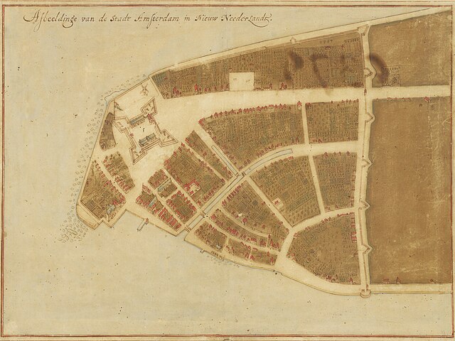
English: Map of New Amsterdam in New Netherland (Manhattan), 1660. Title: "Afbeeldinge van de Stadt Amsterdam in Nieuw Neederlandt." Made by Johannes Vingboons (1616-1670), a cartographer of the VOC. Based on surveys by Jacques Cortelyou (1625–1693). The Grand Duke of Tuscany, Cosimo III de’ Medici (1642-1723), travelled to Amsterdam, the Netherlands in 1667. He was fascinated by Vingboons' work and bought watercolor paintings with mediation by Pieter Blaeu (1637-1706). The paintings were exhibited in his Florentine Villa di Castello.[1] |
| Date | |
| Source | New York Historical Society - https://www.nyhistory.org/exhibitions/new-york-before-new-york-the-castello-plan . Image url: https://web.archive.org/web/20240212181141/https://images.prismic.io/nyhs-prod/3016cf7a-44f1-484c-9de7-53facb6ab21a_Carte+di+Castello+18.jpg The map (Carte di Castello 18) is at Biblioteca Medicea Laurenziana, Florence. |
| Author | Johannes Vingboons (cartographer), Jacques Cortelyou (surveyor) |
| Other versions |
 |
Licensing
|
This work is in the public domain in its country of origin and other countries and areas where the copyright term is the author's life plus 100 years or fewer. | |
| This file has been identified as being free of known restrictions under copyright law, including all related and neighboring rights. | |
- ↑ De ontdekking van de wereld. University of Groningen Library (October 2, 2019). Archived from the original on June 29, 2022.
File history
Click on a date/time to view the file as it appeared at that time.
| Date/Time | Thumbnail | Dimensions | User | Comment | |
|---|---|---|---|---|---|
| current | 03:34, 13 April 2024 | | 3,888 × 2,916 (4.28 MB) | User-duck | Cropped borders to center using CropTool with lossless mode. |
| 18:52, 12 February 2024 |  | 4,000 × 3,070 (4.54 MB) | Artanisen | Corrected brightness and contrast | |
| 16:59, 12 February 2024 |  | 4,000 × 3,070 (4.2 MB) | Artanisen | Uploaded a work by Johannes Vingboons (VOC-cartographer), Jacques Cortelyou (surveyor) from New York Historical Society - https://www.nyhistory.org/exhibitions/new-york-before-new-york-the-castello-plan . Image url: https://images.prismic.io/nyhs-prod/3016cf7a-44f1-484c-9de7-53facb6ab21a_Carte+di+Castello+18.jpg with UploadWizard |
File usage
No pages on the English Wikinews link to this file. Pages on other Wikimedia projects are not listed here.
Global file usage
The following other wikis use this file:
- Usage on arz.wikipedia.org
- Usage on de.wikipedia.org
- Usage on en.wikipedia.org
- New Amsterdam
- Peter Stuyvesant
- Wall Street
- Manhattan
- Financial District, Manhattan
- New York City
- Whitehall Street
- List of cities with defensive walls
- Castello Plan
- Jacques Cortelyou
- List of coastal fortifications of the United States
- New Netherland settlements
- Jan Everts Bout
- Harbor Defenses of New York
- Manhattoe
- Cartography of New York City
- History of Manhattan
- Usage on en.wikivoyage.org
- Usage on es.wikipedia.org
- Usage on fi.wikipedia.org
- Usage on fr.wikipedia.org
- Usage on gu.wikipedia.org
- Usage on gv.wikipedia.org
- Usage on he.wikipedia.org
- Usage on hi.wikipedia.org
- Usage on hu.wikipedia.org
- Usage on hy.wikipedia.org
- Usage on id.wikipedia.org
- Usage on it.wikipedia.org
- Usage on ja.wikipedia.org
- Usage on kn.wikipedia.org
View more global usage of this file.
_Castello_Plan_1660.jpg)
_Castello_Plan_1660.jpg)