File:The pathway of regional integration or separation.png
Jump to navigation
Jump to search

Size of this preview: 799 × 219 pixels. Other resolutions: 320 × 88 pixels | 977 × 268 pixels.
Original file (977 × 268 pixels, file size: 18 KB, MIME type: image/png)
| This free media file is from Wikimedia Commons. Its description page is included below. |
Summary
| Description |
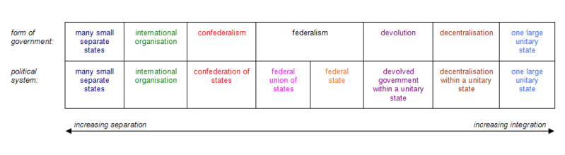
English: This diagram illustrates the various forms of government, and their associated political systems, located along the pathway of regional integration or separation. |
| Date | |
| Source | Law, John (2013) 'How Can We Define Federalism?', in Perspectives on Federalism, Vol. 5, No. 3, Figure 2 and Footnote XX, pp. E104, E116. |
| Author | Federalunion |

|
File:The pathway of regional integration or separation.svg is a vector version of this file. It should be used in place of this PNG file when not inferior.
File:The pathway of regional integration or separation.png → File:The pathway of regional integration or separation.svg
For more information, see Help:SVG. |
Licensing
I, the copyright holder of this work, hereby publish it under the following licenses:

|
Permission is granted to copy, distribute and/or modify this document under the terms of the GNU Free Documentation License, Version 1.2 or any later version published by the Free Software Foundation; with no Invariant Sections, no Front-Cover Texts, and no Back-Cover Texts. A copy of the license is included in the section entitled GNU Free Documentation License. |
This file is licensed under the Creative Commons Attribution-Share Alike 3.0 Unported license.
- You are free:
- to share – to copy, distribute and transmit the work
- to remix – to adapt the work
- Under the following conditions:
- attribution – You must give appropriate credit, provide a link to the license, and indicate if changes were made. You may do so in any reasonable manner, but not in any way that suggests the licensor endorses you or your use.
- share alike – If you remix, transform, or build upon the material, you must distribute your contributions under the same or compatible license as the original.
You may select the license of your choice.
File history
Click on a date/time to view the file as it appeared at that time.
| Date/Time | Thumbnail | Dimensions | User | Comment | |
|---|---|---|---|---|---|
| current | 20:15, 31 May 2016 | 977 × 268 (18 KB) | Federalunion | Clarification to make fully consistent with forms at source reference. | |
| 12:19, 7 May 2016 | 966 × 266 (21 KB) | Federalunion | Even out column width (last column was too narrow, distorting the graphic). | ||
| 20:41, 25 April 2016 | 969 × 262 (17 KB) | Federalunion | {{subst:Upload marker added by en.wp UW}} {{Information |Description = {{en|This diagram illustrates the various forms of government, and their associated political systems, found along the pathway of regional integration or separation. [[:en:federali... |
File usage
No pages on the English Wikinews link to this file. Pages on other Wikimedia projects are not listed here.
Global file usage
The following other wikis use this file:
- Usage on bn.wikipedia.org
- Usage on ceb.wikipedia.org
- Usage on en.wikipedia.org
- Usage on it.wikipedia.org
- Usage on jv.wikipedia.org
- Usage on kcg.wikipedia.org
- Usage on kn.wikipedia.org
- Usage on ne.wikipedia.org
- Usage on sd.wikipedia.org
- Usage on sq.wikipedia.org
- Usage on sr.wikipedia.org
- Usage on ta.wikipedia.org
- Usage on tr.wikipedia.org
- Usage on vi.wikipedia.org
- Usage on yo.wikipedia.org