File:Départements et régions de France.svg
Jump to navigation
Jump to search

Size of this PNG preview of this SVG file: 588 × 550 pixels. Other resolutions: 257 × 240 pixels | 513 × 480 pixels | 821 × 768 pixels | 1,095 × 1,024 pixels | 2,190 × 2,048 pixels.
Original file (SVG file, nominally 588 × 550 pixels, file size: 362 KB)
| This free media file is from Wikimedia Commons. Its description page is included below. |
Summary
| Description |
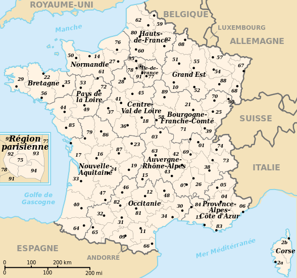
 English: Departements and region of France. French geographics objects use ISO 3166-2:FR for ids.
Español: Mapa de los departamentos franceses.
Français : Départements et régions de France avec leurs préfectures. Les objects géographiques français utilisent les identifiants provenant de ISO 3166-2:FR |
||
| Date | |||
| Source | Own work | ||
| Author | bayo | ||
| Permission (Reusing this file) |
|
||
| Other versions |
[]
|
![(français) Départements (numérotés) et régions de France avant 01/01/2016 (nommées, non colorisés) [source of all the following derivatives]](http://commons.wikimedia.org/wiki/File:D%C3%A9partements_et_r%C3%A9gions_de_France.svg)


![(français) Départements (numérotés) et régions de France avant 01/01/2016 (non nommées, non colorisées) [rendu amélioré] (version utilisée pour rendre la carte clicable par département)](http://commons.wikimedia.org/wiki/File:D%C3%A9partements_et_r%C3%A9gions_de_France_-_Noname-2016.svg)


![(français) Départements (numérotés) et régions de France avant 01/01/2016 (nommées et colorisées) [regions named/colored]](http://commons.wikimedia.org/wiki/File:D%C3%A9partements%2Br%C3%A9gions_(France).svg)
![(français) Départements (numérotés) et régions de France avant 01/01/2016 (nommées et colorisées) [15% magnified, rapid JPEG format 5x faster]](http://commons.wikimedia.org/wiki/File:France_departements_regions_narrow.jpg)
![(français) Départements de France (numérotés, non colorisés)[numeric labels, uncolorized]](http://commons.wikimedia.org/wiki/File:D%C3%A9partements_de_France.svg)


![(multilingue) Départements de France (sans aucun libellé) [No labels]](http://commons.wikimedia.org/wiki/File:D%C3%A9partements_et_r%C3%A9gions_de_France_vide.svg)
File history
Click on a date/time to view the file as it appeared at that time.
| Date/Time | Thumbnail | Dimensions | User | Comment | |
|---|---|---|---|---|---|
| current | 11:50, 26 April 2024 | | 588 × 550 (362 KB) | Jack ma | - correction of region limits (closing of Grand Est and Nouvelle-Aquitaine) |
| 09:02, 12 April 2024 |  | 588 × 550 (438 KB) | Jack ma | Updated French administrative regions of 2016 | |
| 16:18, 22 July 2014 |  | 588 × 550 (466 KB) | Seudo | Fixed orthograph mistake ("région parisenne") and added hyphens in Pays-de-la-Loire | |
| 02:55, 16 May 2009 |  | 588 × 550 (466 KB) | Archimatth | Une seule préfecture varoise | |
| 07:26, 20 June 2008 |  | 588 × 550 (467 KB) | Bayo | patch region/departement id with ISO 3166-2:FR | |
| 09:02, 17 June 2008 |  | 588 × 550 (474 KB) | Bayo | {{Information |Description= |Source= |Date= |Author= |Permission= |other_versions= }} | |
| 16:56, 10 May 2008 |  | 588 × 550 (459 KB) | Bayo | region name bigger, patch typo of some names | |
| 20:34, 22 May 2006 |  | 588 × 550 (459 KB) | Bayo | patch : typo | |
| 15:11, 17 April 2006 |  | 588 × 550 (459 KB) | Bayo | ajout de l'échelle | |
| 14:45, 17 April 2006 |  | 588 × 550 (455 KB) | Bayo | *'''description''' : Départements et régions et de France avec leurs préfectures. *'''auteur''' : bayo Category:Maps of departements of France Category:Maps of régions of France == Licensing == {{PD-self}} |
File usage
No pages on the English Wikinews link to this file. Pages on other Wikimedia projects are not listed here.
Global file usage
The following other wikis use this file:
- Usage on af.wikipedia.org
- Usage on ceb.wikipedia.org
- Usage on da.wikipedia.org
- Usage on es.wikipedia.org
- Usage on eu.wikipedia.org
- Usage on fi.wikipedia.org
- Usage on fr.wikipedia.org
- Aménagement du territoire en France
- Discussion modèle:Fragéoloc
- Wikipédia:Atelier graphique/Images à améliorer/Archives/Novembre 2006
- Wikipédia:Atelier graphique/Images à améliorer/Archives/Mai 2007
- Discussion utilisateur:Mirondia
- Utilisateur:Wikisoft*/Tests cartes
- Discussion utilisateur:Sting/Archive 08
- Patrimoine juif d'Alsace
- Patrimoine juif de Lorraine
- Patrimoine juif du Sud-Est de la France et de la principauté de Monaco
- Patrimoine juif d'Île-de-France
- Patrimoine juif du Sud-Ouest de la France
- Patrimoine juif des régions du centre, partie ouest
- Patrimoine juif du Nord et de l'Est de la France (sauf Alsace et Lorraine)
- Patrimoine protestant de Lorraine
- Usage on ia.wikipedia.org
- Usage on la.wikipedia.org
- Usage on lt.wikipedia.org
- Usage on oc.wikipedia.org
- Usage on pt.wikipedia.org
- Usage on qu.wikipedia.org
- Usage on se.wikipedia.org
- Usage on vi.wikipedia.org