File:Gz-map2.png
Jump to navigation
Jump to search
No higher resolution available.
Gz-map2.png (328 × 352 pixels, file size: 8 KB, MIME type: image/png)
| This free media file is from Wikimedia Commons. Its description page is included below. |
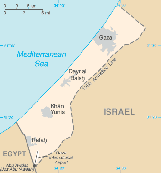
| Description | A map of the Gaza Strip | |||
| Date |
Taken from CIA World Factbook website on 28 August 2006. Please note that this is not the original CIA map; it has been edited to remove the text Israeli-occupied with current status subject to the Israeli-Palestinian Interim Agreement - permanent status to be determined through further negotiation (compare e.g. [1]). |
|||
| Source | CIA World Factbook | |||
| Author | CIA | |||
| Permission (Reusing this file) |
Public domain, as is all content from the CIA factbook
|

File history
Click on a date/time to view the file as it appeared at that time.
| Date/Time | Thumbnail | Dimensions | User | Comment | |
|---|---|---|---|---|---|
| current | 13:16, 20 May 2021 | | 328 × 352 (8 KB) | Jul059 | Lossless file size reduction |
| 16:36, 9 July 2012 |  | 328 × 352 (25 KB) | Quite vivid blur | Distinguishable colours | |
| 02:29, 2 December 2007 |  | 328 × 352 (15 KB) | Kordas | Updated and fixed image | |
| 02:59, 25 March 2007 |  | 328 × 352 (26 KB) | Tewfik | {{Information |Description=A map of the Gaza Strip |Source=[https://www.cia.gov/cia/publications/factbook/geos/gz.html CIA World Factbook] |Date=12 April |Author=CIA |Permission= Public domain, as is all content from the CIA factbook {{PD-USGov-CIA-W |
File usage
The following 4 pages use this file:
Global file usage
The following other wikis use this file:
- Usage on am.wikipedia.org
- Usage on ast.wikipedia.org
- Usage on azb.wikipedia.org
- Usage on cy.wikipedia.org
- Usage on de.wikinews.org
- Usage on en.wikipedia.org
- History of the State of Palestine
- User:Kzzl/Gzzl/talk
- List of cities in the Gaza Strip
- Wikipedia:Village pump (policy)/Archive 27
- Wikipedia:Wikipedia Signpost/2014-08-06/Traffic report
- Wikipedia:Wikipedia Signpost/Single/2014-08-06
- Wikipedia:Top 25 Report/July 27 to August 2, 2014
- Wikipedia:Top 25 Report/August 3 to 9, 2014
- Wikipedia:Top 25 Report/May 16 to 22, 2021
- Usage on en.wikiquote.org
- Usage on en.wiktionary.org
- Usage on es.wikipedia.org
- Usage on es.wikinews.org
- Usage on fa.wikipedia.org
- Usage on ff.wikipedia.org
- Usage on fo.wikipedia.org
- Usage on fy.wikipedia.org
- Usage on hy.wikipedia.org
- Usage on id.wikipedia.org
- Usage on incubator.wikimedia.org
- Usage on io.wikipedia.org
- Usage on it.wikipedia.org
- Usage on jv.wikipedia.org
- Usage on ka.wikipedia.org
- Usage on km.wikipedia.org
- Usage on lmo.wikipedia.org
- Usage on lt.wiktionary.org
- Usage on mai.wikipedia.org
- Usage on mg.wikipedia.org
- Usage on mk.wikipedia.org
- Usage on ne.wikipedia.org
- Usage on sco.wikipedia.org
- Usage on sk.wikipedia.org
- Usage on sq.wikipedia.org
- Usage on ta.wikipedia.org
- Usage on th.wikipedia.org
- Usage on ur.wikipedia.org
- Usage on wa.wikipedia.org
- Usage on wuu.wikipedia.org
- Usage on xmf.wikipedia.org
- Usage on yi.wikipedia.org
- Usage on yo.wikipedia.org
View more global usage of this file.